Cabeza Prieta Natural History Association
A Visitor's Guide to El Camino del Diablo
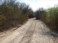
Leg 2a: Darby Well Road to Tule Well
"You can't see anything from a car; you've got to get out of the ... contraption and walk, better yet crawl, on hands and knees, over sandstone and through the thornbush and cactus. When traces of blood begin to mark your trail you'll see something, maybe."
Ed Abbey, Desert Solitaire

Take a moment here to double check that your gas gauge reads "full," your tires have air, and the ice chest is stowed for a bumpy ride. No services from here to Yuma; 130 miles of bad road lie ahead. Reset odometer. Make sure that you have your Cabeza Prieta range permit from https://luke.isportsman.net and that you check in by phone with Goldwater-West to give them your permit number or use the website http://www.rangeaccess.com/RangeAccess.aspx. The Goldwater number is on the back of your permit, but Darby Well Road may be your last reliable cell phone connection.
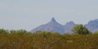
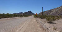 Black Mountain (3,008 feet), standing to left of the road ahead, is an eroded remnant of a basaltic volcano that once covered a much larger area. The horizontal banding is due to differences in hardness between the basalt flows and softer tuffs that have been tilted and faulted. The brown-black color tinged with red is typical oxidation and weathering for such rocks. Also called Darby Mountain and Ko'okomadkam, which is O'odham for "belonging to blue paloverde" that grow abundantly along the arroyos around the mountain.
The New Cornelia Mine's rock dump to the right is its own mountain, made of rock that once sat atop the ore deposits. In fact, three mountains were leveled to dig the pit, a hole that now is 1,100 feet deep and varies from 1¼ to 1½ mile in diameter. East of Ajo, tailings from the crushed and processed ore were pumped as slurry across the highway and settled in ponds on top of the enormous pile, now made even taller by a cap of mine rock "paving" the top to prevent the dust from blowing away.
WWI ace Frank Luke, Jr., worked a few summers at the Ajo mine before enlisting as a pilot in the Army. He flew a Spad XIII and became America's second-ranked ace with 18 air victories -- 14 balloons and 4 aircraft -- to his credit before being killed in battle in 1918. Known as "The Balloon Buster" for his prowess at downing observation balloons, a more difficult target because they were heavily defended by anti-aircraft fire, he was awarded the Medal of Honor. Luke Air Force Base, which manages the Goldwater Range-East, was named for him, but the border community of Lukeville was named for the related Charles Luke family who bought 67 acres here in 1920 and later sold it in 1960.
Mile 1.8. 32° 20'22"N, 112° 50'58"W. Key Junction. Darby Well Road and Scenic Loop Road. Bear straight ahead. Road to right continues the Scenic Loop around the mine and returns to Ajo.
At one time a community of Hia-ced O'odham lived around the wells. Respect private properties and fences along the road.
As you go.... Miles 2.2 to 12.2: Land from here to Organ Pipe is administered by the US Bureau of Land Management (BLM) for multiple use, including recreation. BLM allows camping on these lands and no permit is required, although all vehicles must stay on designated roads and trails. Driving in washes is prohibited. BLM also provides an RV camping area near Gunsight Wash at Highway 85. The nearest BLM office is in Phoenix, 623-580-5500.
The BLM manages 247 million acres of federal land in order "to conserve, protect, and enhance fish, wildlife, plants and their habitats for the continuing benefit of the American people." This means managing land for multiple uses, including grazing, mining, coal and oil leases, timber harvesting, and a wide variety of recreational activities. BLM also administers the National Landscape Conservation System, that features 873 special areas and approximately 32 million acres of national conservation areas, wilderness areas, wild and scenic rivers, national scenic and historic trails, and national monuments such as Sonoran Desert National Monument near Gila Bend. The agency also administers 700 million acres of subsurface mineral rights across America.
 Mile 2.6. 32°19'48"N, 112°51'29.6"W. Locomotive Rock and photo point directly ahead. Distinctive fanglomerate rock-formation whose silhouette from certain directions resembles a small, old-time railroad locomotive with flared smokestack.
As you go.... Miles 3 to 12.2: These desert lands were once ranched by the John W. Cameron family that came to Arizona in 1880. John and his sons drilled wells in the Ajo area (including Valentine, Lower, Adobe, and Bandeja wells). About 2005 they amicably retired their grazing allotment, taking cattle off the range, and today Jeff Cameron maintains wells for wildlife water, especially the imperiled Sonoran pronghorn. Fences have been removed in coordination with the National Park Service and the US Fish and Wildlife Service. At one time the Cameron's leased allotment included land and wells within the Cabeza Prieta refuge as well as BLM land. Historically the allotment totaled about 144 sections (144 square miles), and the ranch headquarters was in Ajo, where the family continues to live.
Mile 9.1. 32°14'24.7"N, 112°52'53.3"W. Key Junction. Large reverse Y junction. Bear left (south). Road to right (southwest) goes to Bandeja Well and Lime Hill.
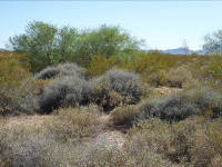
Note many small washes supporting paloverde trees (both Parkinsonia florida, blue paloverde, and P. microphylla, foothills paloverde), wolfberries (Lycium spp.) (Lycium parishii) (Lycium exsertum) (Lycium berlandieri), and other shrubs, with creosote (Larrea tridentata) bushes, ocotillos (Fouquieria splendens), and ironwood trees (Olneya tesota) on the ridges. In spring these washes are abuzz with native bees and other pollinators.
 Creosote is sometimes called greasewood, though that name also applies to other shrubs in the West, including chamise, desert broom, spiny greasebush, snakeweed, and seepwood. Creosote is not the source of the wood preservative creosote, which is a petroleum byproduct. Creosotes range from the Great Basin Desert of Nevada to southern Argentina; and they are common to all four North American Deserts: Sonoran, Chihuahuan, Mojave, and Great Basin. The species here is Larrea tridentata. Norwegian ethnographer Carl Lumholtz learned to love creosote, writing,
"To me the greasewood is a symbol for health and an example of cheerful existence under adverse circumstances....It may be compared to a person radiant with health and good cheer, for which he is liked, though he may not be handsome. Were I a poet, I should sing the praise of the modest greasewood of sterling qualities."
And naturalist Gary Nabhan wrote a book called The Desert Smells Like Rain, honoring the bush's sublime and unforgettable fragrance, particularly following rain showers. Creosote is a keystone species, one on which many other species depend.
Mile 12.2. 32° 12'01"N, 112° 54'20"W. Organ Pipe Cactus National Monument boundary.
Its headquarters is five miles north of Lukeville and the Mexican border. Camping is available near the visitor center, with primitive camping at Alamo Canyon. Managed by the National Park Service, the monument was established in 1937 and embraces 330,687 acres, with 95% of that being federally designated Wilderness Area.
The monument is a member of the UNESCO biosphere reserve system, placing it alongside internationally renowned biological, geologic, and historical wonders of the world such as Yellowstone, Grand Canyon, Denali, Big Bend, Rocky Mountain, and 41 other U.S. national parks. The designation highlights a park's natural and cultural resources as well as the people and communities around the park, so that the park can be managed in a wider context and be a good neighbor. Problems such as air pollution, threatened species, and even climate change affect the park and communities alike. The program, sanctioned by the United Nations Educational, Scientific, and Cultural Organization (UNESCO) and run by the US Man and the Biosphere Program (MAB), has proven successful over the past 40 years. Each nation retains sovereignty and jurisdiction over its own sites. Biosphere reserves highlight three very different, but equal, aims: conservation of genetic resources, species, and ecosystems; scientific research and monitoring; and promotion of sustainable development in communities of the surrounding region.
Also, Organ Pipe is a sister park for El Pinacate and El Gran Desierto de Altar Biosphere Reserve immediately south of Organ Pipe. Their staffs work together to increase and share information, and to conserve resources, such as protecting Sonoran pronghorn and fighting invasive weeds. A model for sister parks is Waterton-Glacier International Peace Park that has worked successfully since 1936 on the US-Canada border.
As you go.... Miles 12.6 to 13.3: In the distance to the southeast you may see traffic on Highway 85. In the terrain between here and there, 13 migrants from El Salvador died from thirst and heat in July 1980 and another 32 children, women, and men were rescued by Border Patrol agents and park rangers after a frantic search. The event is recounted in the book Escape! by Aron Spilken, who presumed that "People who did such work must be harsh and insensitive.... What I found instead were public-spirited people with a difficult job.... Certainly the desperate energy that [the agents and officers] invested in saving the Salvadorans' lives could only have come from a certain nobility of spirit." Imagine being an agent searching this landscape to find men, women, or children who do not want to be found or who are totally exhausted by heat and lying immobile under a bush. Their death may be only hours away. Can you find them in time?
Mile 14.5. 32°10'55"N, 112° 55'38"W. Growler Pass. At times the road is rough and rocky, showing bedrock. In the hills to the north are nearly a dozen prospect holes where old-time miners tried to find their fortunes but found nothing of commercial value. The pass separates the Growler Mountains to the north and Bates Mountains to the south.
As you go.... Miles 14.6 to 15.2: Cholla (Cyndropuntia bigelovii) forest with several species of cholla, including many chain-fruit cholla (Cylindropuntia fulgida), whose hanging fruits are a staple food of Sonoran pronghorn. Native peoples have used the buds of several species of cholla as a nutritious food for a very long time. Wendy Hodgson answers many of your questions in her book Food Plants of the Sonoran Desert (2001).
Mile 15.1. 32°10'56.8"N, 112°56'40.8"W. Rescue beacon. These beacons allow migrants and persons lost in the desert to summon help from Border Patrol. In some places civilian humanitarian groups, such as Humane Borders, provide water stations where migrants will find a blue barrel of emergency water.
In spring, this is a favorite area for kestrels and phainopeplas, especially in ironwood (Olneya tesota) and paloverde (Parkinsonia florida & Parkinsonia microphylla) trees.
As you go.... Mile 15.3 to 16.0: Scarface Mountain to the north. In the southern Growler Mountains to the west are several mine adits and caves that provide shelter for bats, including the fruit- and nectar-eating lesser long-nosed bat (Leptonycteris curasoae yerbabuenae) that may fly as many as 60 miles a night in search of food, especially flowers and fruit of saguaro (Carnegia gigantea) and organ pipe cactus (Stenocereus thurberi). Along this stretch you may also notice a number of places where abandoned trails or off-roading incidents are being restored by NPS to replicate the natural habitat.
 As you go.... Miles 16.1 to 19.1: Growler Mountains to the north. These rugged basaltic mountains extend about 25 miles to the north-northwest. Their distinctive western escarpment contrasts with their more gently sloping eastern side, and makes for dramatic photographs.
Mile 16.2. 32° 10'11.8"N, 112° 57'06.1"W. T-junction. Gate to Bates Well and ranch. Turn left to visit the ranch or turn right to continue your trip on El Camino del Diablo.
 The first of several wells here was dug about 1880, and different families ranched here over the years, with the Robert L. Gray family running cattle in the monument from about 1919 to 1978. The buildings are fine examples of pragmatic desert ranch architecture. Be cautious of honeybees in and around the buildings.
On seasonally pleasant hikes along Growler Wash and into Growler Canyon, watch for mule deer and javelina. A few mountain lions roam from north of Ajo to the border, using the Growler, Bates, and Puerto Blanco Mountains as home. The Bates Mountains are volcanic, consisting of layered and eroded basalts.
The O'odham name for Bates Well is Juni Kaachk ("place of ripe saguaro (Carnegia gigantea) fruit") indicating a favorite area to harvest the nutritious fruit that was also used in ceremonial drinks.
 Mile 16.9. 32°10'17.6N, 112°57'49.6"W. Viewpoint of Kino Peak to the south. Named for Jesuit padre Eusebio Kino who in the late seventeenth and early eighteenth centuries traveled the route now called Camino del Diablo. Believe it or not, there is a "secret" hiking route to the summit (strenuous all-day hiking plus some scrambling), but if you reach the summit, you'll enjoy a grand view and likely see desert bighorn sheep or at least their fresh tracks and scat.
Mile 17.0. 32°10'19"N, 112°57'58"W. Growler Mine site. Only photos remain.
Optimistic miners once worked the hills here digging shafts trying to find gold, silver, or copper. Little or no profit was reported but many stocks were sold to distant investors. Ore from the mine ran 20% to 40% copper, with its silver going 100 oz. to the ton, or so investors were told. The Growler site included about 73 acres and four claims: the Copper Hill, Yellow Hammer, Copper Flat, and Daisy. Growler at one time featured a boarding house, three boilers, an Ingersol-Rand air compressor, and two steam hoists.

First worked by Frederick Wall who named the mine after his friend, John Growler, the mine consisted of several claims and workings, primarily the Growler and Yellow Hammer. By 1916 the mine reached peak population and production under leadership of George H. Morrill, but by 1917 production ceased. Until the claims were sold to the National Park Service in 1957, a series of miners -- including Bert Long, Charles Greer, and John Cameron -- tried to restart operations, but they were thwarted by high costs, rising groundwater in the shafts, and low market prices for ore. The Arizona Bureau of Mines estimates all years of production from the Growler claims totaled 12,000 pounds of copper, 2 ounces of gold, and 200 ounces of silver with a sum value of $2,000.
Water was available at the nearby Bates Well, but a heavy flow of water in the mine -- about 300 gallons a minute -- was encountered at 117 feet, leading to flooding and the perpetually expensive problem of pumping it out. At one time a crew of 25 men used the mine shaft water as their only water source, but its taste and potability were dubious. A mining engineer who appraised the claims in 1956 wrote, "Certainly the purity of the water from the old mine workings would be questionable. It probably has a small copper content which might be mildly poisonous, as well as the essence of rotting mine timbers and perhaps the bodies of a few smugglers and bootleggers who have long used such mountain fastnesses along the Mexican border."

Bert Long's mine, 268 feet deep, produced a respectable amount of copper. The Yellow Hammer, 250 feet deep, seems to have been the richest copper shaft with a mineralized fault vein, one to five feet wide. Long claims 43 tons of 50% copper ore were shipped in 1917. Long had about three or four tons of high grade ore and about 50 tons of low grade ore on the dump. The Daisy claim was little more than disturbed ground with no production. The Copper Flat was no mine at all, but was the plot where Long sometimes lived in his 24 feet x 55 feet, three-room adobe home with a sheet-metal roof.
Eventually the water pumps proved too expensive to run, and operations ceased. A watchman named Ziegler was hired to guard the Growler. His diet consisted almost entirely of oatmeal mush and canned milk, and he made periodic trips to buy supplies in Ajo by walking there and back again while pushing a wheelbarrow. He refused rides from passing cars.
It's a pleasant walk to the top of the hill with a rewarding vista. Along the way you'll meet an array of chain-fruit cholla (Cylindropuntia fulgida), saguaro (Carnegia gigantea), and ocotillo (Fouquieria splendens).
Mile 20.0. 32°09'42.6"N, 113°00'44.4"W. An example of head-cutting erosion; as the road bed erodes, land on uphill side also erodes, submitting to running water. Kino Peak is to the southeast.
 As you go.... Miles 20.1 to 22.1: This is Sonoran pronghorn (Antilocapra americana sonoriensis) country. These fleet-footed animals prefer open spaces and a variety of foods including chain-fruit cholla buds and spring forbs. An international task force of agencies and dedicated biologists has teamed in a heroic effort to help this endangered subspecies rebound from 21 animals in the US in the year 2002 to nearly 400 hundred today. Pronghorn resemble antelope, but are classified as a unique family (Antilocapridae) within the order Artiodactyla (even-toed ungulate mammals). These are Antilocapra americana sonoriensis.
Turnaround or stopping points are available every mile or two for your driving convenience. Watch out for approaching traffic, including heavy trucks and road graders, along this single lane roadway.
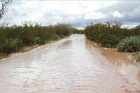
Mile 20.9. 32°09'22.4", 113°01'36.0"W. Growler Wash may look insignificant, but it can flow or flashflood several times a year, usually during summer thunderstorms. It is fed by Cherioni Wash (with headwaters in the Diablo Mtns), Alamo Wash (from Ajo Mtns), Cuerda de Lena Wash (from Pozo Redondo & Little Ajo mtns), and Kuakatch Wash (from Ajo Mtns & Gunsight Hills).
Excellent place to closely view blue paloverdes (Parkinsonia florida), velvet mesquites (Prosopis velutina), desert willows (Chilopsis linearis), desert broom (Baccharis sarothroides), catclaw acacia (Senegalia greggii, formerly Acacia greggii), California threefold (Trixis californica), and various vines, plus a variety of birds, as well as find shade for yourself and bathe in desert fragrances.
As you go.... Miles 21.3 to 22.0: The road is being eroded by traffic and running water, creating a ditch. You can help reduce erosion by keeping your vehicle on the road. Resist driving on the berm unless necessary. When turning around, utilize one of the pullouts available along the way, or make a three-point or T-turn as if you are pulling into or backing into a parking lot stall and then returning the way you came.
And you will come upon freshly smoothed stretches of road. This is the handiwork of a Border Patrol agent diligently "dragging" the road so that agents can "read" the road for foot or tire prints of smugglers or migrants crossing the road. The dragging may benefit you by smoothing out the road's washboard corrugations, but its real-life-and-death purpose is to rescue migrants and catch criminals. Agents request that when possible, drive the ruts, not the smooth "chalkboard" or the berms. Dragging is done at 3 to 5 mph, and requires hours of work.
 Note the exposed root systems of various plants. Most desert plants stand in shallow soil atop rock or in deep but relatively dry soils. Even the mighty saguaro's (Carnegia gigantea) roots are shallow, spreading widely but seldom deeper than 4 inches so that they can benefit from even light rain. Saguaros do have short taproots about 2 feet deep that help anchor them, but they may be toppled by high winds, especially if the soil is moist. Rainfall from an average rain may percolate only a few inches into older or caliche-layered soils, favoring plants with shallow roots such as bursages (Ambrosia deltoidea) and chollas (Cylindropuntia fulgida) (Cyndropuntia acanthocarpa). Rain infiltrates deeper into younger or sandy-gravelly soils, allowing creosote to extend its roots deeper, though its shallow roots allow it to persist in drier soils, too. Woody desert plants may survive by dropping their leaves when stressed (drought dormancy), while cactus rely on moisture stored in their pulp to carry them through dry times between rains.
 Mile 22.1. 32°08'47.3"N, 113°02'31.8"W. This dense plant community includes ratany (Krameria spp.) (Krameria bicolor), which is semi-parasitic on the triangleleaf bursage (Ambrosia deltoidea). You may also find several queen-of-the-night cactus (Peniocereus greggii) and an assortment of shy springtime flowers, such as desert chicory (Rafinesquia neomexicana) and desert pincushion (Chaenactis stevioides).
Mile 22.2. 32°08'43.8"N, 113°02'38.8"W. Key Junction. Intersection with Pozo Nuevo Well road and route to Tinajas Altas. Go straight (southwest) for your Tinajas Altas adventure. Road to left (southeast) goes to Pozo Nuevo, Quitobaquito, and Lukeville.
Attentive visitors have seen Sonoran pronghorn in the creosote flats of this area.
Mountains ring this broad Growler Valley: Agua Dulce Mountains to the south-southwest, Granite Mountains to the northwest, Growler Mountains to the north, and Bates Mountains and Kino Peak to the east.
 The cone-shaped Sheep Peak stands far to the north, just west of the main Growler Mountains escarpment. It has been used as a guide post for travelers walking to Charlie Bell Well, and it can be seen from Interstate 8.
Mile 22.8. 32°08'30.4"N, 113°03'15.9"W. Rescue beacon. Although migrants may have walked a day or two from the Mexican border to reach this spot, others have walked much farther. One woman walked all the way from Honduras, an eight month trek. In summer, people on foot can die within a few hours in the open desert, even if their canteen is not empty. Heat exhaustion and heat stroke are very real threats here. From 1981 through May of 2016 the Pima County Medical Examiner's office confirmed 334 migrant deaths in this region. That breaks down to 153 in Organ Pipe, 77 in Cabeza Prieta, 38 in Goldwater-West, 10 in Goldwater-East, and 56 on BLM lands in the Ajo area. A running tally and additional information is at http://www.humaneborders.info/ .
As you go.... Miles 23.3 to 24.3: The nearly pure stands of creosote (Larrea tridentata) may appear monotonous, but seasonally these flats throb with a variety of colorful flowers, especially in nutritious soil around the bushes. What is there without creosote?
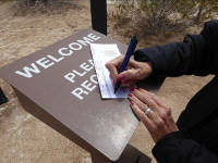 Mile 24.8. 32°07'50"N, 113°05'08"W. Cabeza Prieta National Wildlife Refuge boundary and Boundary Camp, a Border Patrol forward operating base. Visitors must obtain a permit beforehand and then sign in at the kiosk, which is about 100 yards west of the tall tower. Permits are available at the Cabeza Prieta visitor center in Ajo, the US Air Force Auxiliary Field south of Gila Bend, the Marine Corps Air Station in Yuma, and at BLM offices in Phoenix. The permits are free and allow access to both the Cabeza Prieta National Wildlife Refuge and parts of the Goldwater Range. Visitors must notify the Goldwater Range before each visit there; contact numbers are on the back of the permit. Permits are required because of special hazards and regulations on the refuge and range. Do not touch, handle, or disturb unexploded military ordnance or any other military equipment or items, including shell casings.
Created in 1939, the refuge covers 860,010 acres with about 93% being Wilderness. It is administered by the US Fish and Wildlife Service. In 2014 the Cabeza Prieta celebrated its 75th anniversary. The US Fish and Wildlife Service manages 150 million acres of federal land "to conserve, protect, and enhance fish, wildlife, plants and their habitats for the continuing benefit of the American people." This mission includes managing 560 wildlife refuges, managing migratory birds -- especially waterfowl, restoring fisheries and wetlands, and protecting endangered species.
The refuge endorses the Leave No Trace ethic, with its seven point creed: 1) plan ahead and prepare, 2) travel and camp on durable surfaces, 3) dispose of waste properly, 4) leave what you find, 5) minimize campfire impacts, 6) respect wildlife, and 7) be considerate of other visitors.
Be careful with campfires, for the refuge has suffered wildfires in the past, particularly 2005. In most years there is not enough dry plant fuel between shrubs, cactus, and trees to carry a fire very far. But in exceptionally wet years, open spaces may fill with new plants, and when they dry out, a fire can sweep many miles. Cactus and most desert plants are not adapted to fire, which is of grave concern because invasive plants like buffelgrass (Cenchrus ciliatus) are adapted, resprouting vigorously after fire and providing heavy stocks of fuel for future fires. Another invasive, Sahara mustard (Brassica tournefortii), reseeds easily, sprouts early, and suppresses native winter annuals by dominating light, water, and soil nutrients, and it too can carry fire. Native annual plants have declined where this mustard is thriving.
The designated Wilderness Area begins 100 feet from the centerline of the roadway. Public vehicles are required to stay within 50 feet of the centerline; law enforcement vehicles may enter the Wilderness in special or emergency circumstances. The refuge has some administrative trails in the Wilderness, but these are for official use only; no public vehicles are allowed and even official traffic is monitored. An administrative trail for law enforcement officers can be seen heading north into the Growler Valley, and an administrative trail goes south to Agua Dulce Pass.
 Boundary Camp, so called because it is on the boundary of Organ Pipe and Cabeza Prieta, operates around the clock. Since construction of this base and Camp Grip, as well as the vehicle barrier along the border, the number of vehicles used for smuggling has been greatly reduced. The tall tower provides electronic observation of the border area as well as communications, and it is part of Border Patrol's network of stationary and mobile observation devices, including drones.
As you go.... Miles 25.0 to 30.0: Pilot training.
Since 1941 the Growler Valley has been a flight corridor for student military pilots on the Barry M. Goldwater Range, which has long been one of the nation's most important training ranges because of its extensive size, year-round-flying weather, few operational limitations, and close proximity to military air bases. Some specified areas of the Goldwater Range are open to the public by permit; all other areas are off-limits due to safety risks. On old maps the range may appear as Williams or Luke gunnery range. Barry M. Goldwater was an Army Air Corps officer who helped set the range's boundaries in 1941 and later became a prominent Arizona senator and presidential candidate. In 2016 the Goldwater Range celebrated its 75th anniversary.
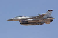
F-16 Fighting Falcon

F-16 above,
F-35 Lightning below.
You may see strange shiny objects standing in the distance, particularly in the Growler and San Cristobal valleys north of you. These are military tow darts used for gunnery target-practice by student pilots training at the Goldwater Range from 1941 into the Cold War era. The darts were unreeled behind the towing aircraft on 1,500 feet of 11/64-inch cable. Student pilots would then practice shooting at the dart. The darts could not be reeled back-in, so they were either jettisoned over the range or, preferably, along Dart Drop Road near Gila Bend Air Force Auxiliary Field south of Gila Bend.
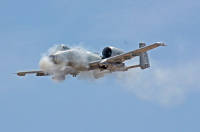
A-10 Thunderbolt
Mile 27.5. 32°06'44.8"N, 113°07'39.9"W. San Cristobal Wash.
 This dense swale of mesquite trees, vines, grasses, and coyote gourds (Cucurbita digitata) is a good place to poke around and find an assortment of seasonal wildflowers. A variety of small mammals, birds, snakes, lizards, and toads also live here. Some of the loudest residents -- Couch's spadefoot (Scaphiopus couchii) and giant desert toads (Bufo alvarius, once called Colorado River toads) -- are active and heard only in the summer rainy season. Signs announce rehabilitation of an old road detour around a treacherous mud hole now crossed by a causeway.
When filled by extreme thunderstorms, this wash runs from near Dripping Springs in the Puerto Blanco Mountains to silt flats a few miles south of Dateland on Interstate 8, though its channel reaches the Gila River. So flat are the valley bottoms that sometimes a channel of San Cristobal Wash takes an alternative route, looping through the Antelope Hills and eventually finding its way to Las Playas.
As you go... Miles 28.4 to 28.6, and 29.5 to 29.7: Portions of the roadway are lined with metal landing mats to reduce erosion and provide footing for vehicles across what was at times a dust bowl. We're reminded of the pioneer Plank Road through the Algodones Dunes west of Yuma. However, this stretch of road requires frequent maintenance because the mats shift from side to side on the soft ground, leaving drivers to straddle mats like a sailor with one foot on the boat and one on the dock -- sometimes the vehicle "falls in" and gets stuck. Notice that the terrain slopes to the north as shown by erosion of the south (left) bank. The Agua Dulce Mountains to the southwest are named for a short stretch of the Sonoyta River where historically the water was fresh, not salty.
 Mile 29.0. 32°06'20.5"N, 113°08'56.3"W. Photo stop. Classic nurse tree south of road. An adult saguaro grew from seed underneath this older ironwood that shaded it from excessive sun, provided richer soil, and hid the seedling from herbivores in its leaf litter.
Mile 29.9. 32°06'11.7"N, 113°09'59.6"W. Key Junction. Y-road junction. Route to the right (northwest) goes to Papago Well. Take it.
Administrative trail to the left is closed to public vehicles and goes to wildlife water catchments. Sheep Mountain (distinct from Sheep Peak, 21 miles to the north) stands west-northwest 3 miles away, while Papago Mountain is west-southwest and 5 miles from here. (There also is a Sheep Mountain in the Gila Mountains, but that is getting ahead of ourselves. As you can tell, bighorn have long fascinated visitors to this region.)
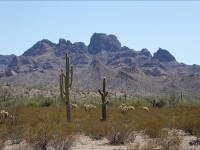
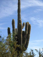
 Mile 30.7. 32°06'34.4"N, 113°10'40.7"W. Photogenic saguaros, with big galleta grass (Hilaria rigida), chainfruit cholla, and other perennial plants as well as seasonal wildflowers and nesting birds. The saguaro is classified as Carnegiea gigantea, with the genus honoring Andrew Carnegie, magnate and philanthropist, who in 1902 funded the Carnegie Desert Laboratory on Tumamoc Hill in Tucson as well as public libraries across America. Gigantea? You've guessed it.
Mile 30.9. 32°06'39.6"N, 113°10'53"W. Cholla Pass. Aptly named for stands of teddy bear and other chollas (Cyndropuntia bigelovii) (Cylindropuntia fulgida). For propagation, chollas rely more on fallen stems taking root than on seeds being dispersed. Species with the widest ranges seem to also have joints that most easily snag passing animals, including us. A pocket comb is the weapon of choice in removing a cluster of spines. For single, large spines you may prefer needle-nosed pliers; for those devilishly small glochid spines, try tweezers.
 In describing the throes of extreme thirst of a prospector who ran out of water along the Camino in 1905 and for five days walked, stumbled, and crawled back to Tinajas Altas, WJ McGee placed cholla in a special hell for someone hallucinating about a drink of water, writing, "The forbidding cholla, spiniest of the cruelly spined cacti, is vaguely seen as a huge carafe surrounding by crystal goblets, and the flesh-piercing joints are greedily grasped and pressed against the face to cling like beggarticks to woolen garments; with the spines penetrating cheeks and perhaps tapping arteries."
Photographers like Jack Dykinga see cholla as picture-perfect subjects for backlit Arizona Highways photos, and birds -- especially thrashers (Toxostoma curvirostre), doves (Zenaida macroura), and cactus wrens (Campylorhynchus brunneicapillus) -- build nests in cholla (Cylindropuntia acanthocarpa), and packrats stack cholla joints to make walls and roofs for their dens.
Mile 32.2. 32°07'25"N, 113°11'50"W. Chinaman Flat. The name reportedly came from Chinese immigrants who wished to farm here sometime in the first half of the twentieth century, though another version says they were smuggled across the border and then murdered here.
Trees and grasses along the band of dry runnels provide an interesting place to walk south along the Deer Hollow drainage, perhaps as far as Antelope Tank (about 3 miles one-way). Sonoran pronghorn (Antilocapra americana sonoriensis) have been seen here as well as mule deer (Odocoileus hemionus crooki) and roosting turkey vultures (Cathartes aura).
Mile 33.0. 32°07'47"N, 113°12'29"W. Vista of the Granite Mountains to the north, as well as Sheep Peak in the Growler Mountains to the northeast.
Mile 34.5. 32°07'48.8"N, 113°13'57"W. Pull-out. From the slopes of the small hill north of the road you can look north toward the Granite Mountains where 14 immigrants died in May 2001 after being abandoned by their smugglers and then becoming hopelessly lost west of the mountains. Border Patrol agents raced to find them and rescued 12 others in the group from certain death in the summer's torrid heat. Those events are chronicled in Luis Urrea's book The Devil's Highway, a book he dedicated "For the dead, and for those who rescue the living." Ironically, the summit of this hill (32°07'54"N, 113°13'59"W) has been used as a lookout post by smugglers to spy on Border Patrol.
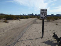 As you go... Mile 36.3: Reminder: the Camino's speed limit is 25 or below. This route is a single-lane jeep trail with two-way traffic.
Mile 38.2. 32°05'57.7"N, 113°16'59.8"W. Y junction. Camino goes west; administrative trail coming in from southeast is closed to public vehicles.
Mile 38.3. 32°05'57"N, 113°17'03"W. Papago Well primitive campground. It has picnic tables, but no ramadas, water, latrines, or trash pickup.
Hikers may find an old eastbound trail to the Papago Mine diggings at the base of Papago Mountain. And bird watchers can always find a variety of birds along the wash and in the flats, such as verdins (Auriparus flavicepes), gnatcatchers (Polioptila melanura), and hummingbirds (Calypte costae), with several owl (great horned owl Bubo virginianus) (western screech owl Megascops kennicottii) species calling at night.
 Mile 38.4. 32°05'57"N, 113°17'13"W. Papago Well. No camping is allowed near the well or wildlife guzzler. Along the washes you can find canyon ragweed (Ambrosia ambrosioides), white burrobush or cheesebush (Ambrosia salsola, formerly Hymenoclea salsola), desert starvine (Brandegea bigelovii), and pigweed or careless weed (Amaranthus palmeri), as well as paloverde trees. The large saguaro near the wildlife guzzler is a favorite hangout for turkey vultures and other birds.
 The well provided water to Papago Mine in the 1890s and early 1900s, but the mine was a bust. In the late 1930s Jim Havins and his family established a ranch here with a two-room cabin, corrals, stock tanks, and windmill. His son Hank Havins ran cattle in the area until the late 1970s, but nothing remains of the ranch. Refuge manager Gale Monson bragged that Jim and Mary Havins baked the best buttermilk biscuits he ever tasted.
And as you effortlessly unscrew the cap on your water bottle, you might recall Kirk Bryan's description of getting a drink here in 1920. "There was...a tripod and pulley erected over the well. Water was obtained by means of a steel cable drawn through a pulley and attached to a sand pump, the sand pump being lowered to water at a depth of 235 feet, filled through a valve at the bottom, and pulled out by attaching the cable to an automobile. A single horse or two men could pull out the sand pump when full, but it is doubtful that a man alone could obtain water."
 Mile 38.5. 32°06'00.7"N, 113°17'16.2"W. Camino bends west (left). An administrative trail runs north (right) to several distant wildlife waters but is closed to public vehicles. The stout sign post on south side of the road once held a US Customs sign telling border crossers to check in at nearest Customs office. Until the late 1970s border travelers who were US citizens could cross the international line into the US where they wished and were required to report for inspection only if importing goods from abroad. Famous agents who patrolled this portion of the border and rode the line horseback from Sonoyta to Yuma include Jeff Milton and Ed Ketchum. Milton was lionized in J. Evetts Haley's book Jeff Milton: A Good Man with a Gun and featured in William T. Hornaday's Camp-fires on Desert and Lava.
As you go.... Mile 40.9: A tall wooden post south of the road marks a control point for the US Army Map Service's mapping project of the early 1960s. Its tag reads "31." Termites, wind, and erosion have toppled most of the posts throughout the region, but for several decades these numbered posts served as road and junction markers. Many regional survey benchmarks and place-names date from this period. For example, benchmarks were named for refuge managers Gale Monson and Norman Simmons, who assisted the surveyors, and this period is when places such as the Sierra Arida, Hummingbird Canyon, and Bean Pass were formally named. The 1960-era maps have been subsequently updated using GPS and laser technology.
As you go... Mile 40.5 to 41.2: Mexico's Sierra Pinacate looms to the south. It is a shield volcano and the summit (3,957 feet) of the Pinacate Lava Field, now included within the Pinacate World Heritage Site and Reserva de la Biosfera El Pinacate y El Gran Desierto de Altar, a 1.7 million-acre Mexican biosphere reserve. The western peak is called Pinacate Peak and is the summit of Volcan Santa Clara. On October 9, 1698, the intrepid Jesuit padre Eusebio Kino and his party were the first Europeans to ascend this peak, and in November 5, 1706, Kino again climbed a peak in the area and reported, "We saw very plainly the connection of this our land with that of the west," fueling his claim that Baja California is a peninsula and not an island. Cartographers had forgotten that Spanish sea captain Hernando de Alarcon proved this in 1540. The eastern peak is sometimes called Carnegie Peak, figuring in a desert travel book Camp-Fires on Desert and Lava by William T. Hornaday.
The name Pinacate is derived from a Nahuatl term, Pinacatl, meaning beetle; in northwestern Sonora the term Pinacate is used for large black stink-beetles in the genus Eleodes (e.g. E. armata). When threatened, the desert stink beetle may stand on its head and spray predators with a foul fluid from its abdomen. O'odham call the mountain S-cuk Do'ag (sometimes spelled Schuk Toak), meaning "black mountain."
 Mile 41.8. 32°05'52.1"N, 113°20'34.0"W. Camp Grip, a Border Patrol forward operating base and de facto rescue station with blinking red beacon atop communications mast. The camp was established in 2002 as a response to the 14 migrant deaths near the Granite Mountains in May 2001 and the terrorist attacks of September 11, 2001. It allows agents to work close to the international line and respond immediately to callouts and emergencies. Agents are the nation's border police and frequently work in areas where no other agency is able to respond to violations, crimes, or rescues. Technically Camp Grip is a mobile base, meaning that it could be disassembled and moved in a few days. The name comes from the slogan "Get a grip" on a problem.
On the south side of the road, a grave and cross pay tribute to Pete, an off-course pelican that landed here and died before an animal rescue specialist could arrive. And ravens frequent the camp, showing a fondness for tearing rubber wiper blades off of the patrol trucks -- who knows why. Savvy agents remove the blades while working here.
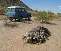
R.I.P.Descanse en paz.
Mile 43.5. A Border Patrol road. No public traffic allowed.
 Mile 44.3. Following good rains, these flats are ablaze with the colors of globemallow (Sphaeralcea coulteri) and other spring flowers.
As you go.... Mile 44.4: Sand hills, visible around the base of Sierra Pinta to the northwest, provide a forest of chain-fruit cholla (Cylindropuntia fulgida) and other edible plants that draw Sonoran pronghorn here. This antelope-like sub-species is smaller and lighter in color than its northern relatives, and adapted for survival in desert conditions.
Pronghorn (Antilocapra americana sonoriensis) are slightly smaller than a white-tailed deer (Odocoileus virginianus couesi) with a shoulder-height of about three feet. The bucks weigh up to 130 pounds, and does up to 110 pounds. Both sexes have horns, with the females' being short and the males' being black and about 10-12 inches long. Their horns have a small tine that gives the species its name: pronghorn. The horns have an outer sheath of fused, modified hair that covers a permanent, bony core. Pronghorns shed the hollow outer sheath each year in fall and grow a new set by summer. Both have extra-long white hair on their hind section that stands up when they are frightened. This can be seen from a distance and serves as a visual locator -- the bold, white markings help pronghorn find each other from long distances on the large, open range. It can also be used as an alarm to let other pronghorn know that danger is nearby. Pronghorn can reach speeds of up to 60 miles per hour on short distances and can maintain a speed of 35 mph for longer distances. If you see pronghorn, please pause to let them pass.
 Pronghorn have keen vision, and they can spot movement several miles away. They are extremely shy and easily spooked. Their wariness, along with their good eyesight and speed, is very important to their survival. They are also well adapted to the desert conditions and during extreme heat are able to raise patches of their stiff hair to release heat. These same hollow hairs serve as insulation during the winter.
Pronghorn (Antilocapra americana sonoriensis) can have twins when food is abundant but most does deliver one fawn that weighs between five and seven pounds. Though typically able to stand a day after being born, fawns will lie very still throughout the day waiting for their mother to come back and feed them, which is typically twice a day. At about six months of age, the young pronghorn will be independent of its mother.
The Sonoran pronghorn has a four-part stomach similar to cows, allowing them to digest the succulent desert vegetation that makes up most of their diet. As desert vegetation dries with the onset of summer, water availability becomes increasingly important for digestive purposes, and pronghorn rely on the fruit of the chainfruit cholla as a source of moisture when water is otherwise unavailable.
As you go.... Miles 44.5 to 47.3: To the south you may notice highway traffic on Mexico Highway 2, a major highway that parallels the borderline and connects mainland Mexico with the Baja California peninsula. Peter Matthiessen's short story "The Wolves of Aguila" is set south of here, on a lonely stretch of road near the Los Vidrios truck stop, though there are no wolves known in the area today.
In the 1920s and 1930s before Highway 2 was even graded, let alone paved, enterprising Mexican drivers braved the fearsome sands from Sonoyta to San Luis Rio Colorado in beefed-up cars carrying passengers and cargo. Some died and all had misadventures, as newspaperman Valdemar Barrios-Matrecitos chronicled in his book Por las Rutas del Desierto, but these "choferes del desierto" and their taxis were the only way to get there. You also may wish to read Guillermo Munro's novel El Camino del Diablo to imagine what that trip was like.
Mile 45.6. 32°05'28.8"N, 113°24'15.1"W. Junction. Go straight ahead (west). A trail created by smugglers and illegal immigrants is now used by Border Patrol to travel south to the border near a now-abandoned truck stop at Los Vidrios on Highway 2, and to travel north to the Growler Valley. Smugglers first carved these wildcat roads, frequently in the dead of night, and Border Patrol followed. Construction of the border vehicle barrier in 2007-2008 has greatly diminished the number of vehicles crossing the border illegally, as well as the scores of smuggling vehicles that were abandoned, sometimes far from any road. As you have noticed, any tire tracks straying off the road may last for many years. Even tracks from the passage of a single vehicle may linger a lifetime, harming the land in subtle but unkind ways.
As you go.... Miles 46.7 to 48.7: You can now say that you are on the Camino del Diablo, also known as the Yuma Trail or Sonora Trail. The road you have been on from Darby Well dates to the 1890s.
The Camino del Diablo was a route from Sonoyta, Sonora, to Yuma, Arizona. From Sonoyta it followed the Sonoyta River until the river turned south. The route then headed northwest and came through the westernmost O'Neill Hills, thereby skirting the jagged flank of the Pinacate lava flows. It possibly passed close by Ortega's Represa, a rock dam just south of Border Monument 179, or perhaps through a low, easy pass north of the monument. It probably passed just north of Las Playas and climbed the Pinta Sands onto the lava flow, going westward approximately where the modern road is. An alternate route to Yuma from Tucson was the Gila Trail that followed the lower Gila River.
El Camino del Diablo was an informal, backcountry route, unlike several other famous royal roads (highways, really) sanctioned by the Spanish crown in the 17th century. In the Southwest these include El Camino Real de Tierra Adentro (connecting Mexico City with Santa Fe, New Mexico, including El Jornada del Muerto), the Camino Real de California (connecting the Spanish missions from Loreto, Baja California Sur, to Sonoma, California, just north of San Francisco), and El Camino Real de los Tejas (connecting Mexico City with eastern Texas and Louisiana). Camino Real means the "royal road" or "king's highway."
As you go.... Mile 46.8: The road slices through stunted mesquite thickets that provide good birding.
Decades ago a low-flying Marine Corps Harrier jet crashed in the playa when it hit a red-tailed hawk (Buteo jamaicensis), and several years later a Border Patrol helicopter crashed in the area. Both pilots walked away.
Mile 47.3. 32°05'35"N, 113°26'02"W. Las Playas. ("Playas" is Spanish for dry lakes or beaches.) This stretch of road is a confusion of braided ruts, so your best bet is to follow the most recent tracks on the widest lane. It's smart to engage four-wheel drive before starting.
This dry, dusty depression may become an impassible mud bog following rains. As the mud dries, a mosaic of deep cracks forms. The Pinacate lava field now blocks arroyos that once flowed southward, creating this internally drained basin and intermittently dry lake. Other nearby dry lakes include Pinta Playa and Dos Playas in the refuge, and Diaz Playa in Mexico 13 miles southeast.
 Perennial plants frequently found near playas include alkali mallow (Malvella leprosa), arrowleaf alkali mallow (Malvella sagittifolia), and hairy ground cherry (Quincula lobata). Kirk Bryan reported in 1925 that "a few small mesquites are found around the border of the clay flat, but the center is without vegetation and is broken by deep cracks, so that it makes a rough roadbed." He noted that tributaries on the western and southern edges of the playas leave numerous depressions where water remains for considerable periods after a rain, and "All the ancient routes from Sonoyta to Yuma came through Las Playas, because there was a good possibility of finding water there and because of the presence of horse feed."
In September of 1861 Raphael Pumpelly survived an Apache attack south of Tucson and fled to California. Along the way he dodged bandits, heat, and thirst. When he and his small band camped at Las Playas they were dog-tired, out of water, and still had a 30-hour ride ahead of them before reaching Yuma. He feared that their horses would not survive and, in turn, he would die. "But during the night the sky was overcast with black clouds, and there came the first rain that had fallen on this desert for more than two years. Never was a storm more welcome; both we and our horses enjoyed heartily its drenching torrent.... A broad sheet of water, only a few inches deep, covered the playa for miles before us, and banished from our minds all fear of suffering."
Mile 48.2. 32°05'38.0"N, 113°26'53.5"W. Cool-weather hike of 1 or 2 miles north to the taller dunes amid seasonal dune flowers -- dune evening primrose (Oenothera deltoides), dune sunflowers (Geraea canescens), sand verbena (Abronia villosa), Ajo lily (Hesperocallis undulata), rare Emory's indigo-bush (Psorothamnus emoryi) -- and fascinating tracks of rodents, kit foxes, snakes, and insects.
 From here Padre Kino and others of his time usually headed northwest across the uncharted sands to reach Heart Tank, guided by Native Americans who lived in the region. Prehistorically there were a number of camps around the playa and dunes, and even in historic times the Hia-ced O'odham for parts of the year had camps at Cabeza Prieta Tanks, Quitobaquito, and south of the Sierra Pinta.
Mile 48.4. 32°05'38.0"N, 113°27'03.8"W. Eastern edge of the windblown Pinta Sands. Photo stops next ½ mile. Following wet summers, the sands may bloom with many flowers, including summer California caltrop (Kallstroemia grandiflora). Following wet winters, visitors may see uncommon displays of blue sand lily (Triteleiopsis palmeri), as well as sand verbena (Abronia villosa), Ajo lilies (Hesperocallis undulata), desert club cholla (Grusonia kunzei), big galleta (Hilaria rigida), primroses (Oenothera deltoides) (Oenothera primiveris), and other plants that prefer or tolerate sandy soil.
Mile 49.2. 32°05'50.9"N, 113°27'53.4"W. Eastern edge of the Pinacate Lava Flow. You may spot Sonoran pronghorn, hawks, and burrowing owls. Patient visitors with good binoculars or 'scopes may be rewarded by observing wildlife and their behavior.
 As you go.... Visitors may be surprised to see non-desert birds almost anywhere along the Camino. Egrets, herons, and grebes have been seen perched or standing in unlikely places along your route. Their preferred habitats are waters like Quitobaquito and shores on the Gulf of California, about 60 miles to the south, but they sometimes feed far from water, may be blown off course, or may alight to rest while flying across open desert. Bird expert Gale Monson reported seeing a flock of 51 white pelicans flying over Heart Tank in Sierra Pinta, the arid mountain range north of here, presumably going from the Sonoyta River to the Colorado or Gila rivers. His essay "The Arizona Desert" in Olin Pettingill's The Bird Watcher's America may be the finest account of birds along the Camino.
And along the Camino somewhere west of Las Playas, members of the 1890s boundary survey were astonished to find "the skeleton of a camel, which, the Mexican guide stated with much relish, had been brought for use on the deserts in northern Sonora and had perished here of thirst." The unfortunate animal probably had escaped or descended from Lt. Edward F. Beale's Camel Corps 1857-1859 experiment using camels for the US Army in the arid Southwest.
Mile 50.0. 32°06'01.2N, 113°28'38.0"W. A friendly place to camp.
 Mile 50.2. 32°06'07.4"N, 113°28'50.1"W. Viewpoint. Looking north from here, you can see the two-tone contact line between the northern light-colored granite and southern dark-colored gniess of Sierra Pinta that gives the range its "pinta" ("speckled" or "painted") name. The sierra represents classic horst-and-graben geology -- one block up (the horst, German for "raised ground"), one block down (the graben, German for "ditch" or "trench") -- of the Basin and Range Province. Most non-volcanic mountain ranges and valleys in Arizona, New Mexico, Nevada, and eastern California trend parallel in one direction: north-south or northwest-southeast. They are being pulled apart by the underlying tectonic plates stretching the land (think faults and earthquakes). The valleys and mountains are linear and slender. Geologist Clarence Dutton famously compared the many narrow, parallel mountain ranges that distinguish the unique topography of the Basin and Range to an "army of caterpillars marching toward Mexico." The summit of Sierra Pinta is BM Pinta at 2,950 feet.
Also find here a seasonal flower show ranging in size from tall prickly poppy or "cowboy's fried eggs" (Argemone gracilenta) to the diminutive devil's spineflower (Chorizanthe rigida, a buckwheat) and other "belly" flowers like Mojave desertstar (Monoptilon bellioides).
Mile 50.1. 32°06'05N, 113° 28'46"W. Parking for walk to Diaz Crater, a shallow sand-filled mystery ring less than a mile north of the Camino. It may be a basalt-rimmed crater and the northernmost of the Pinacate craters, but further research is needed. William K. Hartmann, Dale Cruikshank, and others at the University of Arizona's Lunar and Planetary Laboratory in Tucson identified it from high-altitude photographs and named it for explorer Melchior Diaz, whose expedition passed near Sierra Pinacate in 1540. The feature is at 32°06'33"N, 113°28'42"W.
Mile 50.5. 32°06'11.1N, 113°29'3.3"W. Nice place to stop and walk out into the lava, with a good view south of Pinacate Peak, a large shield volcano now included in Mexico's renowned Pinacate Biosphere and World Heritage Site.
A Mexican microwave tower stands atop a hill to the southwest. Black lava-capped buttes resemble miniature Cabeza Prieta peaks. Swales of big galleta grass (Hilaria rigida), white bursage (Ambrosia dumosa) and triangle leaf bursage (Ambrosia deltoidea) are home to rodents and cottontail rabbits, as can be seen in the many trailways running between bushes or holes. With practice and help from books like Pinau Merlin's A Field Guide to Desert Holes, you can figure out who lives in the dozens of different kinds of holes, depressions, and burrows. Many desert species spend most of their lives underground, especially in the heat of the day. Gila monsters (Heloderma suspectum), for example, spend about 95% of their lives in subterranean seclusion.
Mile 51.5. Campspot with view of Sierra Pinta to the north.
 Mile 51.6. 32°06'33.4N, 113°30'09.5"W. Nameer's grave or marker along south side of road. To date no one has unlocked the mystery of who is commemorated here or why, but the marker predates 1930. Let us know if you solve the case.
As you go.... Miles 51.7 to 51.9: Stay right as the road goes through swale of mesquite (Prosopis velutina), bursages, and big galleta that includes desert fleabane (Erigeron lobatus), fermina (Cottsia gracilis), mallows (Sphaeralcea spp.) (Sphaeralcea coulteri) and other interesting plants. Black-tailed jackrabbits (Lepus californicus eremicus) thrive here. They "freeze" until approached too closely, and then they hop and leap away with amazing speed, frequently making a wide zig-zag loop back to the same bush.
Mile 52.2. 32°06'42.5"N, 113°30'41.1"W. Looking northward you can see the light/dark Sierra Pinta contact. Southward you can see black lava-capped buttes. Try a cool-weather hike of about ¾ mile to nearest butte north of road, or about ¾ mile to Monument Bluff south of the road.
From the road, Monument Bluff looks like a flat-topped hill, but if you make the hike and climb up to the rim, the interior crater is impressive and well worth the effort. If you hike about a half-mile farther south from the crater, you'll reach the U.S.-Mexico border and will see Boundary Monument 181 at 32°05'43.6"N, 113 °30'48.8"W. A total of 258 of these monuments were placed along the international boundary by a joint US-Mexico commission between 1892 and 1895, beginning at El Paso, Texas, and ending at the Pacific Ocean south of San Diego, California. Most of the monuments were iron obelisks like this one, but some were made from brick and mortar. The line of the boundary passes through the apex of the obelisk, so half of the monument is in the U.S., and half is in Mexico. They were placed at regular intervals in locations where the next one along the line could be observed using surveying instruments. Many are located on flats or low hills like this one, #190, but some atop mountain peaks are very difficult to reach, as seen in David Taylor's book Monuments (Radius Books, 2016).
The workers encountered great hardship placing the monuments along the section of border between Sonoyta, Mexico and the Colorado River, owing to the long distances and the lack of water. Everything needed was transported in wagons, including barrels of water, cement, the monuments themselves, and all provisions. In some places, the monuments and building materials had to be pulled up cliff faces by rope. It took about 400 pounds of Portland cement for each monument base, plus additional local gravel and sand, all mixed together with about 30 gallons of water. The iron monuments themselves weighed 710 pounds. All work was by hand. The work party along this stretch consisted of 29 men. Transportation included 4 baggage wagons, 2 water tank wagons, 2 spring wagons, 6 pack animals and 5 riding animals -- in all, 41 animals.
The vehicle barrier that now runs along the border in this section was completed in 2008. Previous to that time there was only a seven-stranded barbed-wire fence here, erected around 1950 to keep cattle from wandering into the U.S. from Mexico. Many miles of the border west of here had no fence at all until the present barriers were erected.
Mile 52.5. 32°06'49.9"N, 113 °31'00.6W. Three rock crosses lie beside the road on the south side. These may have been made recently. Few rock crosses along the Camino date to the nineteenth century. Like memorial crosses along Southwest and Mexican highways today, crosses may commemorate someone's death here instead of being an actual grave.
Mile 53.1. 32°06'59.7"N, 113°31'36.8"W. Speed limit enforcement zone reminder: stay alive below 25.
Cinder flats, probably ash and stones expelled from one of the craters to the south. Most sand and loess soil on this lava flow has been blown in by wind. The lava flow you have been traveling across stands 10-25 feet above the surrounding area.
 Mile 54.4. 32°07'28.3"N, 113°32'50.0"W. Campsite on south side of road. Good view of peaks to the north and west foreshadow a rocky stretch of road ahead.
Somewhere along this stretch of road Raphael Pumpelly and his family camped in 1915. He wrote,
This camp in the lava field was one of the most attractive of the expedition. There were none of the desert trees -- leafless palo verdes and palo fierro [ironwoods] -- but there were great masses of flowering plants and some beautiful white lilies. And there was, scattered here and there, the strange ocotillo (Fouquieria splendens) with its many slender, branchless stems, nearly ten feet high, radiating from one root, each stem bearing one scarlet blossom floating like a pennant at the top. Eastward beyond the lava field and its cones, and far away over the desert plain, crumbing mountains shone red in the sunset glow.
Mile 54.6. 32°07'30.8"N, 113°33'01.6"W. Western edge of the Pinacate Lava Flow and the beginning of more Pinta Sands, which wrap around the lava flow like a horseshoe. Here the sands are less "duney" than the east side.
 As you go.... Miles 54.6 to 57.0: The road here is far below the level of the surrounding land. With the passing of vehicles and occasional roadwork, desert roads channel water. A summer thunderstorm of over six inches of rain here about 1991 flash-flooded and eroded several feet of soil, creating a ditch and scour holes up to seven feet deep. The deepest holes have since filled in, but at one time the banks stood taller than the refuge patrol truck.
At mile 55.8 and other places note the root systems and abandoned rodent burrows in the wall of the bank, plus flowers that flourish here, and the layers of soil.
Mile 54.8. 32°07'36.6"N, 113°33'17.0"W. Close encounter with Sahara mustard (Brassica tournefortii), an invasive cool-season annual that threatens to crowd out native plants, including some of our showiest flowers and richest foods for wildlife. In contrast to this stand of mustard, 0.6 miles to the west you may find open spaces with stands of Spanish needles (Palafoxia arida v.arida), primroses (Oenothera spp.), wooly desert marigold (Baileya pleniradiata), dune sunflower (Helianthus niveus ssp.tephrodes), and button encelia (Encelia frutescens). But next year you may find this flower patch bare or overloaded by Sahara mustard (Brassica tournefortii). Seeds of most annual wildflowers may remain viable of years. Desert iguanas and round-tailed ground squirrels are seasonally active. In this vicinity, an abundance of white-lined (also five-lined) sphinx moth caterpillars (Hyles lineata) may be seen on the evening primrose (Oenothera deltoides) flowers in good flower years. In the evening, adult moths may be seen flying around among the flowers gathering nectar. These are sometimes called "hummingbird moths" because of their resemblance to hummingbirds.
Mile 57.0. 32°08'28"N, 113°35'21.7"W. Approximate western extent of the Pinta Sands.
 Mile 59.8. 32°09'26.9'N, 113°37'33.3"W. Note changes in vegetation along roadway: mallows, including pink velvet-mallow (Horsfordia alata), desert club cholla (Grusonia wrightiana), and white bursage (Ambrosia dumosa), which is better adapted to a hotter and drier climate than triangle-leaf bursage. Roadrunners like these areas, too, finding lizards, snakes, beetles, and grasshoppers to eat.
As you go.... Mile 62.3: Large ironwood nurse trees for saguaros (carnegia gigantea) and other cactus. Blue paloverdes (Parkinsonia florida) along dry washes, and plentiful teddybear chollas (Cylindropuntia bigelovii). Do you see any saguaros 1 to 4 feet tall?
Saguaros are emblematic of the Sonoran Desert and world famous, but hard to spell. Even world-famous botanist Daniel T. MacDougal goofed when he first came to the Southwest in 1905. He spelled it "suwarro," but was gently corrected by Yuma hotel proprietor Herbert Brown, who told him the proper Spanish is "saguaro," or he could make it English with "sahuaro," if he liked. But, "we [Arizonans] will hate SUWARRO as we hate the Devil."
As you go.... Mile 63.8. Keep an eye open for desert bighorn sheep crossing from one mountain to another or feeding on fresh leaves on trees along the washes, grasses, forbs, or even barrel cactus. Bighorn may feed a mile or more into the flats, but they prefer steep slopes for bedding and raising lambs. These desert bighorn are Ovis canadensis mexicana, a distinct subspecies.
Mile 63.8. 32°10'52.3"N, 113°41'08.7"W. Dry-weather campsites in the sandy washes. Interesting stands of desert hummingbird bush (Justicia californica) along banks, and fermina (Cottsia gracilis) or slender janusia vines (Janusia gracilis) can be found entwined with other plants, including desert lavender (Condea albida), brittlebush (Encelia farinosa), velvet mallow (Horsfordia alata), catclaw (Senegalia greggii), and mistletoe (Phoradendron californicum), a favored food of phainopeplas (Phainopepla nitens).
Mile 64.3. 32°10'58.3"N, 113°41'26.0"W. Good sites for camping and hills to climb. Park here for hike to Salazaria Canyon to the south, and a good place to see bladder sage (Salazaria mexicana), named for one of the Mexican civil engineers who helped survey the US-Mexico boundary in 1854.
Mile 64.5. 32°10'59.7"N, 113°41'47.3"W. A veritable desert garden and good place to see elephant trees (Bursera microphylla), desert agave (Agave deserti ssp.deserti), ironwood (Olneya tesota) and paloverde trees (blue paloverde Parkinsonia florida) (foothill paloverde Parkinsonia microphylla), brittlebush (Encelia farinosa), ratany (White Rhatany Krameria bicolor) (Range Rhatany Krameria erecta), ocotillo (Fouquieria splendens), a teddybear cholla (Cylindropuntia bigelovii) forest, and other attractive or interesting desert plants.
The marvelous stands of elephant trees (Bursera microphylla) along the western Camino provide fruit for Gray Vireos (Vireo vicinior), which otherwise eat insects most of the year. The vireo's range overlaps the elephant tree's, suggesting a mutual dependence: the bird relies on the tree for fruit during winter, and the bird distributes the tree's seeds.
 As you go.... Mile 64.9: 32°11'01.3"N, 113°42'12.5"W. Note showy flowers of Parish goldeneye (Bahiopsis parishii) and parasitic desert mistletoe (Phoradendron californicum) in trees.
Imagine you are a 49er driving an oxcart or walking on foot to California -- how far have you come, and how far must you go?
Mile 65.3. 32°11'08.4"N, 113°42'29.6"W. Two roadside rock crosses on the ground south of road; possibly associated with the 49ers. WJ McGee, who traveled the Camino in 1901, observed "Its course was marked by the pitiful milestones of solitary graves, each with its cruciform heap of pebbles."
Mile 65.6. 32°11'21.9"N, 113°42'41.7"W. Dry-weather camp in wash. Note desert lavender (Condea albida, formerly Hyptis emoryi), a favorite for a variety of native bees and Africanized honeybees. Too, you'll probably see a jackrabbit here. With luck, you may see Sonoran Silverbush (Argythamnia brandegeei) growing on hot, south-facing slopes.
On a cool day, peakbaggers might enjoy a very steep and rough hike from here to the unnamed high point of the Tule Mountains, easily seen about 1.3 miles to the southwest as the buzzard flies, but probably closer to 2 miles on foot. Take a map and a good supply of water and follow the wash that crosses the road here southwards to the mouth of a canyon. Stay in the bottom of the drainage and follow the canyon all the way to the top. You won't need ropes, but it is very rugged with 1,150 feet of elevation gain. Only recommended for hikers that are experienced and highly-motivated. The summit is at 32°10'28.3"N, 113°43'17.9"W (2,307 feet). Benchmark (BM) Tule is here. You might notice some discarded lumber and wire lying around, left by the original surveyors in 1920. They erected poles with flags and beacons to make the points easier to see when viewed from similar control stations far in the distance. Only a handful of high peaks were used as primary control points during the 1920 survey. All of the other survey markers you might come across in this region date from the 1960s.
As you go.... Mile 65.7: Black-capped Cabeza Prieta Peak is on horizon to the northwest (roughly straight ahead).
Mile 66.0. Another favored dry-weather camping spot.
Mile 66.8. 32°11'58.2"N, 113°43'41.3"W. Administrative trail to the southeast; no public vehicles allowed. Around 1900 a wooden signboard near here instructed travelers, "Go back and fill your canteen" at Tule Well. This is a nice spot to picnic and admire elephant trees (Bursera microphylla) on the hillside.
Mile 68.0. 32°12'46.6"N, 113°44'25.6"W. Administrative trail south to Tuseral Tank, a wildlife waterhole constructed in 1948. It is a pleasant cool-season walk of about 2 miles one way.
Dry-weather campsite in wash at mile 68.1.
Mile 68.7. 32°13'22.2N, 113°44'48.4"W. Interesting mixes of plants along road, especially near rocky outcrops. Seasonally find stickleaf (Mentzelia involucrata), desert sunflower (Geraea canescens), odora (Porophyllum gracile), desert spineflower (Chorizanthe rigida), and desert trumpet (Eriogonum inflatum). As you have seen in many places along the Camino, ratany is found close to other plants, especially bursage, because ratany is semi-parasitic and needs a host plant. Two ratanys occur in this region: range ratany (Krameria erecta) and white rhatany (Krameria bicolor, formerly K. grayi). Tiny barbs on the range ratany fruit range the length of the shaft, whereas white ratany fruit spines are barbed only at the tip, like a harpoon for Ahab's great white whale. Another parasite that you may see along the Camino in cooler weather is desert broomrape (Orobanche cooperi) -- it looks like brown or purple asparagus with pretty purple and yellow flowers.
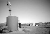 Mile 69.0. 32°13'34.7"N 113°44'59.5"W. Tule Well Junction.
Junction
Tinajas Altas head west (left) from the junction. | Christmas Pass road goes north (right) to Tacna
- Prelude and Map
- Introduction
- Leg 1a: Ajo to junction of Darby Well Road and Highway 85
- Leg 1b: Organ Pipe to junction of Darby Well Road and Highway 85.
- Leg 2a: Darby Well Road to Tule Well
- Leg 4: Tule Well to Tacna
- Leg 2b: El Camino del Diablo, Tule Well to Tinajas Altas
- Leg 3a: Tinajas Altas to Goldwater Range northern boundary
- Goldwater Range northern boundary to Yuma and Interstate 8
- Goldwater Range northern boundary to Wellton and Interstate 8
- Leg 3b: Tinajas Altas to Fortuna and Interstate 8
- Alternate route From Leg 3b to Interstate 8
- Epilogue
Photo Credits:
Photo #1
Photos 2 - 13
Copyright Creative Commons
HTML & Programing by
Thomas R. Powell