Cabeza Prieta Natural History Association
A Visitor's Guide to El Camino del Diablo
Leg 1b: Organ Pipe to junction of Darby Well Road and Highway 85
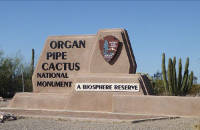
Re-set odometer to 0.0. Restrooms and drinking water are available at the visitors center, along with information, publications, and displays. Permits for the Cabeza Prieta and Goldwater Range are not available here, but can be obtained in Ajo at the Cabeza Prieta office, 1611 North Second Avenue.
Your last gas, food, lodging, or reliable cellular service from here to Yuma are at Lukeville, Why, or Ajo. Head back to Highway 85.
Mile 0.1. 31°57'14"N, 112°48'00"W. Junction with Highway 85. Turn north (left).
The National Park Service (NPS) manages 84 million acres of federal land in order "to conserve the scenery and the natural and historic objects and wildlife therein, and to provide for the enjoyment of the same in such manner and by such means as will leave them unimpaired for the enjoyment of future generations." NPS administers more than 400 sites, including national parks, monuments, historical sites, memorials, battlefields, wild and scenic rivers, seashores, preserves, trails, recreation areas, and a dozen other designations.
Mile 2.8. Tillotson Peak wayside overlook and parking on east side of highway. The peak is the summit of the Diablo Mountains (3,374 feet) and named for Minor R. Tillotson, a National Park Service regional director during 1940s and 1950s. The Diablo Mountains, the small but spectacular and rugged range immediately west of the Ajo Mountains, were formed when a massive block of rhyolite faulted off of the main Ajo Range. It can be argued that the Tillotson segment merits its own name, or that both are really just part of the Ajo Mountains.
As you go . Miles 3 to 8: Organ Pipe radio 1610 AM provides information on camping and activities in the park. In 2016 the National Park Service celebrated its 100th anniversary.
Twenty-two miles of Highway 85 through the park have been designated a Scenic Roadway by the Arizona Department of Transportation because of its visual, historic, and cultural significance, as well as providing a memorable visual impression, being free of visual encroachment, and forming a harmonious composite of visual patterns. Much of the Sonoran Desert ecosystem can be seen from the road itself and has been set aside for preservation. The geology seen from the road features splendid rock formations in the Ajo Mountains, Diablo Mountains, Puerto Blanco Mountains, and Bates Mountains. Looking north you can see the Little Ajo, Pozo Redondo, and Growler mountains.
State Route 85 itself is also a historic road, and has been recognized as part of the Historic State Highway System. The roadside displays a multitude of desert plants including saguaro (Carnegia gigantea), creosote (Larrea tridentata), mesquite (velvet mesquite) (Prosopis velutina), ocotillo (Fouquieria splendens), brittlebush (Encelia farinosa), cholla (Cyndropuntia acanthocarpa) (Cyndropuntia bigelovii) (Cylindropuntia fulgida), prickly pear (Opuntia engelmannii), and, of course, organ pipe cactus (Stenocereus thurberi). After a wet winter, you may see a riot of color: gold poppies (Eschscholzia californica), blue lupines (Lupinus sparsiflorus) (Lupinus arizonica), pink owl clover (Castilleja exsertus), and yellow brittlebush. In late spring, yellow, white or orange cactus flowers offer their own spectacle.
This scenic roadway does have a Camino del Diablo connection, for it roughly parallels a route taken by some miners traveling between Ajo and Yuma beginning in 1854 when Andrew B. Gray and Peter Brady surveyed a railroad route from Texas to the Pacific Ocean. Along the way, the survey party collected mineral specimens from Ajo with hopes of developing a mine there. The Arizona Mining and Trading Company was formed, and some of its employees as well as supplies for the mine came by horseback on the Camino from Yuma to Sonoyta, then north to Ajo, using tinajas at Wild Horse Tank and Alamo Canyon that are east of Highway 85. George Kippen, a special messenger for the company during 1855-1859, took this route several times, and in his diary reported frequent trips by wagon or pack mule from Sonoyta to Ajo carrying food, especially flour, and driving cattle for beef. Eventually the company decided that the Camino was too dry and dangerous, so it elected to transport supplies and ore along Jaeger's Wagon Road from Ajo to the Gila River near Stanwyx, and then to Yuma.
Mile 9.7. 32°05'29"N, 112°46'29"W. Alamo Wash and road. Continue straight to reach El Camino. Turn east (right) for Alamo Canyon and campground.
Take a look at Alamo Wash. It looks peaceful enough, but during the summer monsoon of 2012 monument employees and visitors witnessed two major flood events in larger canyons of the Ajo Range. The first occurred on August 16 when 2.3 inches fell in early afternoon west of Tillotson Peak, joined by 2.8 inches in Alamo Canyon in mid-late afternoon. During the second and larger event that peaked on September 10, flood waters at both the culvert at mile 66.5 and the bridge at Alamo Wash overtopped Highway 85, leaving several sections of backcountry road impassable. This flood was the culmination of six continuous days of rain in the Ajo Range, which began on September 6 and lasted until September 11.
Flood waters in Alamo Wash scoured a large expanse of the adjacent floodplain and uplands, removing large trees and saguaro cacti that were hundreds of years old. A substantial portion of the flow overtopped the Alamo Wash floodplain and flowed through a pass in Tillotson Ridge and into the wash at mile 66.5 on Highway 85. Arizona Geological Survey and US Geological Survey researchers calculated the total discharge at 17,600 cubic feet per second. For the Alamo Wash basin, there is a 0.2% probability that this would occur in any given year (also known, somewhat misleadingly, as a 500-year flood; however, this does not mean this type of flood occurs at regular 500-year intervals, just that it is a relatively rare event on human time scales).
Imagine the wash briefly turning into a river the size of the Colorado River flowing through the Grand Canyon! Can you imagine a string of river rafts or dories coming down Alamo Wash? Desert flooding can be almost unimaginable when looking at a dry arroyo, but evidence of past flash-flooding is everywhere around us. Flash floods usually subside within hours, so if the road is blocked by running water, your best bet is to park on high ground and enjoy the show.
Mile 12.3. Ajo Mountain wayside overlook and parking on west side of highway. No facilities. The large Valley of the Ajo, extending to the north and west, is bounded by fault block mountains and filled to an unmeasured depth by sediments from the surrounding mountains.
The Ajo Mountains feature high peaks and deeply cut canyons sculpted from rhyolite, andesite lava flows, and tuffs at least 2,000 feet thick. These block-faulted volcanics formed in the mid-Tertiary orogeny, 36 to 17 million years ago. The higher elevations support many "sky island" relict plants that were more wide-spread in cooler, wetter Pleistocene times, before the advent of the Sonoran Desert beginning about 10,000 years ago. These include Red Berry Juniper (Juniperus arizonica), littleleaf mulberry (Morus microphylla), scrub oak (Quercus turbinella), and Sonoran Desert rosewood (Vauquelinia californica ssp.sonorensis). Here the Hia-ced O'odham collected wild tepary beans (Phaseolus acutifolius v.acutifolius) and hot peppers called chiltipines (Capsicum annuum v.glabriusculum). These and other native foods can be tasted at Desert Rain Cafe in Sells, Arizona.
The knob-headed Montezuma Peak, a sacred place for the Tohono O'odham, who call it Monchisum (Montezuma) or 'Oks Dak ("place where a woman is sitting"), can be seen to the northeast.
Mile 17.1. 32°12'02"N, 112°45'34.4"W. Organ Pipe northern boundary. Entering BLM lands.
 Mile 17.3. Border Patrol check-point. Agents intercept people and contraband that cannot legally enter the US. The Customs and Border Protection agency combines the roles of the Border Patrol and Customs departments to enforce laws involving immigration and importation. In the 1930s agents like Jeff Milton and Ed Ketchum literally camped with their bedrolls beside the road and flagged cars down.
Mile 19.8. Bridge over Gunsight Wash. Picnic area with tables. Camping west of the highway on BLM land, but no facilities.
Three-quarters of a century ago the Border Patrol office was shaded by the ironwood tree at the bridge. And in 1915, during the throes of the Mexican Revolution, Venustiano Carranza emerged as the political leader of Mexico, forcing Pancho Villa and his rebels to retreat. "As a result of that victory...," writes Kirk Bryan, "450 Villistas crossed the boundary near Ajo. Charles Puffer, as justice of the peace, with the help of Messrs. [Ruben] Daniels and [John] Cameron, arrested the whole 450 as disturbers of the peace and menace to the peace and safety of the town of Ajo. They were held until on the arrival of immigration inspectors, they could be duly admitted to the United States." Bryan undoubtedly heard this story first-hand, for Charles Puffer was his assistant on the survey of water resources in southwestern Arizona.
Mile 21.7. 32°15'56"N, 112°44'23"W. Community of Why. Also called Rocky Point Junction.
Gas and food are available, with camping at Coyote Howls Campground and RV Park. At junction of Highway 85 with Highway 86 to Tucson, go straight ahead (north) toward Ajo, unless you wish to try your luck at the Tohono O'odham Nation casino a short distance southeast of the junction.
The name reportedly arose from a common question fielded by local businesswoman Peggy Cater: "Why live here?" as well as a pun on highway "wye" or "Y." "Why" has been used since about 1965. Anthropologist Henry Dobyns notes that the O'odham word for deer is the homonym "huawi," and desert mule deer do inhabit this area. Coyote Howls is the English equivalent of the O'odham name Ban Hi:nk. Why is also home of a famous laundromat: "Why Wash," leading to existential questions like the "Why Senior Citizens" highway marker and the "Why Not" store.
Mile 22.4. US Border Patrol's Ajo Station. Built in 2012, it sits on 30 acres and provides nearly 54,000 square feet of administrative and detention space for 500 agents as well as parking, equipment, repair stations and a helipad. 850 North Highway 85, Why, AZ 85321-9634. Phone: (520) 387-7002. The station's area of responsibility encompasses over 64 miles along the international border and nearly 7,000 square miles of land roughly the size of Connecticut and Rhode Island combined. In contrast to today's operation, the 1987 station consisted of 25 agents and in the 1930s the Ajo office had only two agents covering the same area.
Much of the Ajo Station's operational area lies within environmentally sensitive or protected lands including the Organ Pipe Cactus National Monument, Cabeza Prieta National Wildlife Refuge, Bureau of Land Management, Barry M. Goldwater Range, and Tohono O'odham Nation. The building was designed and constructed with energy savings in mind. Solar panels supply roughly half of the station's electrical needs during daylight hours, due in large part to natural lighting that greatly reduces the need for daytime lighting. A highly efficient lighting and air-conditioning system also reduces operating costs, demonstrating Border Patrol's commitment to being good stewards of the environment. Ajo Station's advanced technologies has earned it a "Gold Certification" from the United States Green Building Council, under the Leadership in Energy and Environmental Design (LEED) program. The Station was constructed at a cost of $28.5 million.
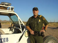 Illegal border crossers commit to several days of foot-travel in a rugged, inhospitable, and perilous desert. Because of the remoteness, a large portion of the area must be patrolled on foot, by horse patrol, ATVs, motorcycles, aircraft, and drones. Agents combine age-old arts of sign-cutting and tracking with modern ground sensors and night vision equipment. Through a combination of personnel, technology, and infrastructure, the Ajo Border Patrol Station continues to apprehend smugglers and undocumented immigrants. Agents rescue many migrants from heat and thirst.
Because migrants or agents may suffer injuries, heat stress, and illnesses, Border Patrol created a special unit of agents trained as Emergency Medical Technicians (EMT) who are skilled in rescue techniques. Called BORSTAR -- for Border Patrol Search, Trauma, and Rescue -- these agents are posted in the field and can respond to remote locations much sooner than urban ambulances or paramedics. BORSTAR agents have even delivered babies.
Miles 23.2, 25.0, and 27.0. Memorial crosses along the highway. These usually indicate the site of a highway fatality and are tended by family and friends especially on All Souls Day (Day of the Dead, or Dia de los Muertos), November 2 of each year. Sites may include crosses, mementoes, shrines, and candles. The Spanish term is "cruz de memoria," and they can be found throughout the Southwest. In his book Beliefs and Holy Places, historian Jim Griffith points out that the tradition was brought from Spain by Catholic padres more than three centuries ago.
Mile 23.5. Note several crucifixion thorn trees (Castela emoryi) along the highway. They resemble paloverde trees with super-stout spines and clusters of seeds that remain on the plant for several seasons before falling to the ground.
As you go.... Miles 24 to 29: Unlike what some newcomers expect, the desert here is neither monotonous nor barren. Sections of nearly pure creosote (Larrea tridentata) stand along the road, but in a mile or two become mixed with mesquite (velvet mesquite) (Prosopis velutina) trees or threaded with washes lined by trees and shrubs.
Mile 29.8. 32° 21'21.5"N, 112° 49'37.5"W. Key junction: Darby Well Road and Highway 85. Highway milepost 44.6.
Turn left (southwest) onto unpaved Darby Well Road (aka Bates Well Road or Scenic Loop). The wide roadside is a good place to pause and reset your odometer. Check your gas gauge for the 130 miles of jeep trail ahead.
Paved Highway 85 continues northwest to Ajo (gas, food, lodging) and Gila Bend.
- Prelude and Map
- Introduction
- Leg 1a: Ajo to junction of Darby Well Road and Highway 85
- Leg 1b: Organ Pipe to junction of Darby Well Road and Highway 85.
- Leg 2a: Darby Well Road to Tule Well
- Leg 4: Tule Well to Tacna
- Leg 2b: El Camino del Diablo, Tule Well to Tinajas Altas
- Leg 3a: Tinajas Altas to Goldwater Range northern boundary
- Goldwater Range northern boundary to Yuma and Interstate 8
- Goldwater Range northern boundary to Wellton and Interstate 8
- Leg 3b: Tinajas Altas to Fortuna and Interstate 8
- Alternate route From Leg 3b to Interstate 8
- Epilogue
Copyright Creative Commons
HTML & Programing by
Thomas R. Powell