Cabeza Prieta Natural History Association
Cabeza Prieta National Wildlife Refuge Location

Cabeza Prieta National Wildlife Refuge
Location
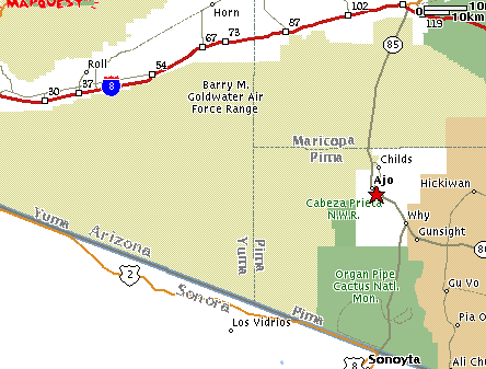
The Cabeza Prieta Wildlife Refuge is situated in southwestern Arizona just west of the town of Ajo. Its southern boundary shares the Mexican/American border with Sonora for 55 miles. The Refuge is 60.5 miles across and 38 miles wide at the widest point. Adjacent to the Refuge on the north and west is the Barry M.Goldwater Military Reservation and to the east and southeast are lands administered by the United States Bureau of Land Management and Organ Pipe Cactus National Monument.
This Refuge lies within the northern portion of the Sonoran Desert which encompasses about a half of the Mexican state of Sonora and from the tip of Baja California northward into southern Arizona and California. Of all the North American deserts, the Sonoran is the richest in plant diversity. There are rare and unusual plant species - some 400 different species identified - partly because of the elevation differences.
To get there, take US Hwy 8, which passes south of Phoenix, Arizona, going east-west from San Diego, Callif., to Casa Grande, AZ. (just north of Tucson). Take a sharp left (or right) south at Gila Bend on State Hwy 85 for about 40 miles and you will be right there in the old mining town of Ajo. The Cabeza Prieta National Wildlife Refuge is a half block South of Rasmussen Road on the West side of the road.
Cabeza Prieta National Wildlife Refuge
1611 North Second Avenue (aka Hwy 85)
Ajo, Az 85321
Telephone: 520-387-6483
Visitor Center office hours: M - F 7:30 - 4:30 (closed for lunch 12 - 1)
Cabeza Prieta National Wildlife Refuge Facts
Cabeza Prieta National Wildlife Refuge History
Copyright Creative Commons
HTML & Programing by
Thomas R. Powell